
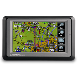
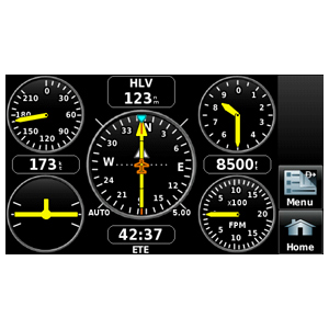
In aviation mode, the aera 500’s detailed chart-style shaded mapping and extensive terrain and aviation databases help you visualize your flight path in relation to nearby navaids, terrain, SUAs, obstructions, and so on. To help keep pilots aware of special airspace activity, over 683 parachute drop zones are detailed in the Americas navigation database. Plus, the addition of private airports and heliports to the database affords even more navigation and emergency “nearest” options. A database-driven terrain advisory feature offers TAWS-like color coding and pop-up alerts when possible obstructions or ground proximity conflicts loom ahead. And with terrain/obstacle data shown at standard 30 arc-second resolution, you’ll enjoy a surprising level of detail on the display. The unit’s graphical Terrain page offers both overhead and vertical profile views of the topography you’re flying over. What’s more, there’s an IFR map mode that lets you display and navigate on high or low enroute airways. You can also pull up MEAs (Minimum Enroute Altitudes) and distances between intersections by touching the airway on the map.
As in all the aera models, the internal GPS updates at a rate of five times per second (5 Hz), which allows your moving map and flight data to display smoothly and continuously. And for added safety, an optional power/data cable (sold separately) makes it easy to interface your aera 500 with the Trig TT21 Mode S transponder in your aircraft, so you can access and display TIS traffic alerts in busy terminal airspace.
Once your aircraft returns to terra firma, the fun of aera navigation continues with full automotive GPS capability and preloaded City Navigator® NT street mapping. Operating much like Garmin’s popular nüvi® line of touchscreen auto navigators, your aera 500 offers voice-guided turn-by-turn directions with text-to-speech audio technology that calls out streets by name. In addition, there’s built-in Bluetooth® support for wireless hands-free calling with your compatible mobile phone. And the aera’s built-in “points of interest” database offers helpful guidance to millions of motels, restaurants, gas stations, ATMs, and other local attractions. To further speed your transition from aircraft to automotive mode, a unique ”smart mount” for the aera offers instant clip-and-go car navigation.
Garmin aera series: It’s the ultimate fly/drive option.

Garmins senaste Flyg-GPS för småflyg. Visar all info för luftrum, såsom kontrollzoner, TMA, etc, etc, med varningar för master etc, och terräng som ligger på samma höjd, eller högre än du själv flyger (går att ställa in olika varningar).
Perfekt GPS för dig som vill försäkra dig om att du inte flyger in i något otillåtet område. Eftersom den visar terrängen och hinder också, kan man i teorin landa på sitt eget fält i total dimma i en nödsituiation.
Kontakta oss för aktuellt pris.
Levereras med: